 There is often a question of why the City of Los Angeles has the crazy borders that it does. Some make sense, like the Pacific Ocean or a singular street like Central or Western Avenues. But then, the are others that seem to make no sense.
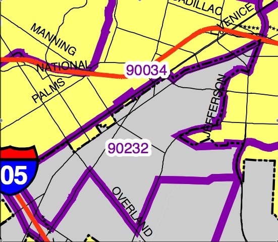
Recently, there was a post that referred to the Museum of Jurassic Technology (MJT) as being located in Culver City. An easy mistake to make, especially since their website claims the erroneous locale. And though they may proclaim such a fallacy on their website, they are, in fact, in the City of Los Angeles - Palms, to be exact. If you call 911, the operator might be confused as to which Police Department to send, but you better believe when it comes to taxes and permits - it's an LA address.
This mistake is east to make, even for residents. Like other areas in the City, palms has a jagged border. The City, as most people know, has grown since 1850 from 25 square miles to just under 469 square miles today. Sometimes that growth produced some jagged edges. With the most recent border change just last year, areas of greater Los Angeles are still trying to be a part of the City. In fact, the City grew by almost 80 acres since 2000 (though, we did lose just over 30 acres in the same timeframe).
So, what's up with the area around Culver City? First, part of the confusion comes from the fact that the 90232 zip code, which is one of Culver City's two zip codes, includes a small portion of Los Angeles along Venice Boulevard in Palms (which includes the MJT). Also, the City line is not clear cut through streets like "along Venice Boulevard." In fact, in some places, both sides of Venice boulevard frontage are Los Angeles, and Culver City either starts with the parcel behind the first one or a few lots beyond. There are even cases, as with West Hollywood's border with Los Angeles, where lots are split!
Some will attest that Los Angeles City borders can sometimes be confusing. In 1911 and 1927 when the borders between Los Angeles and Culver City were established, things probably made sense. Times change, so maybe it's time that is confusing... or perhaps, change?
Special Feature:
You can see how & when portions of the city were added to the growing metropolis here.

2 comments:
Just like with the West Hollywood (and Beverly Hills borders), it's a result of annexing some properties one-by-one (in exchange for access to city water).
What's really fun is Robertson between Wilshire and Burton: There's a jagged border and because Beverly Hills and L.A. have different street numbering systems you can go from 350 N to 150 S on the same block (150S is actually north of 350N too!).
The day that I noticed this (350 N is where my doctor's office), I was wondering about this, then opened my paper to the LA Times article about the jagged borders.
A great post about a subject most Angelenos don't think much about. The map you linked to is very interesting.
By and large, most of these borders don't make a lot of sense, and I have a feeling the border between Culver City and Los Angeles never made sense, not even in 1911 and 1927. It's a relic of political machinations that are probably lost to history.
Today, we have LAFCO, which ostensibly makes sure annexations are handled sensibly. I suppose the weird Culver City border and the intriguing "Shoestring" annexation down to Wilmington wouldn't be permissible today.
I often wonder how greater Los Angeles would be different if places like Hollywood, Venice, and Watts had remained independent cities and were never absorbed by the City...
The numerous "unincorporated islands" governed by the County are another fascinating topic that I've wanted to explore. As you know, West Hollywood was one such island prior to its incorporation in 1984. Why is it that these areas were never annexed by the City?
When I began to do zoning enforcement for the County, I was surprised to learn that about half of the area we generally consider to be "South Los Angeles" is administered by the County, not the City. In a lot of places, the border was mysterious -- in some palces, one side of a residential street is in the City, the other in the County. I made the mistake of citing folks in the City a few times.
The issue of confusing civic borders extends beyond Los Angeles. Take a look at the San Gabriel Valley, and cities like San Gabriel and West Covina in particular.
A lot of the border confusion extends beyond the City's actual corporate boundaries. Angelenos seem to love denying that they live in the City of Los Angeles. Street signs and ZIP codes refer to places like Canoga Park, Tujunga, and Harbor City...I have no doubt that some folks in Studio City and San Pedro don't fully understand that they are citizens of Los Angeles.
Post a Comment