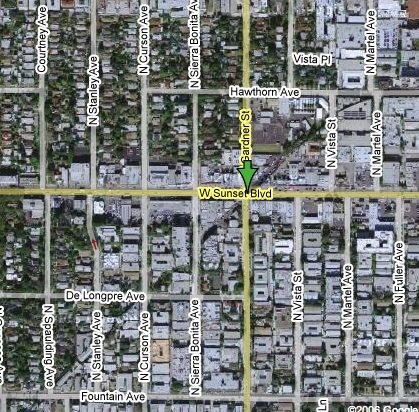
 A reader, Tim, asked what the "slash" across Hollywood/West Hollywood was. So, to answer, look no farther than the former Pacific Electric "red car" lines.
The route from Downtown came to Hollywood via the Glendale Avenue Tunnel, past Echo Park Lake, onto Sunset Boulevard, and then onto Hollywood Boulevard at Hillhurst. The route continued down Hollywood Boulevard to La Brea, where the tracks went in a southwesterly direction from "in street" to a "private right-of-way" (and therefore no longer in the street). This lasted for 2 blocks before going back "in street" on Hawthorn Avenue and then cutting southwesterly again at Martel Avenue. This private right-of way is what has left a slash through Hollywood. It is most obvious as you drive down Sunset near Gardner Street and look at the diagonal property lines that formed the private right-of-way. "There is now some public parking by the City in the former right-of-way at this location.) If you want to see photos of the entire Hollywood Boulevard Line, including part of the slash, check out this site.
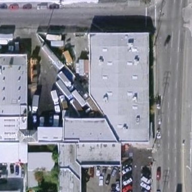
What's most interesting, though, is the way Buildings were designed based on the right-of-way. Evidence of these old Pacific Electric Lines are still seen across the City. Look at Vineland at Chandler where you can see the right-of-way that curved between properties:
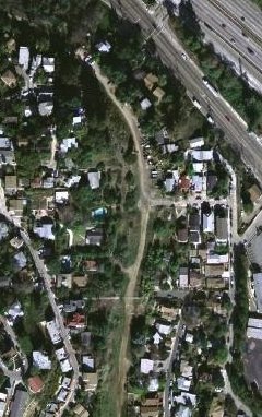
You can also see the Glendale Line's remnants in the Elysian hills that led to Atwater Village:
And many Red Car lines became street routes we still use today, like at Chandler & Van Nuys Boulevard:

Yes, the Red Cars' legacy lives on...

19 comments:
Very nice post. You might note that if folks want to ride the Red Cars, they can do so any weekend at Orange Empire Railway Museum in Perris, California. They can visit http://www.oerm.org for more details
Daniel
P.S.: I've created a syndication for you on LiveJournal as user la_city_nerd
I heard that where the rows of coral trees stand in San Vicente Blvd. in Brentwood was a former PE track.
You are correct, 01:05 anon. The medians in both Boulevards San Vicente contain former PE trackage. Burton Way, the "son of San Vicente," also has old Red Car track.
Other major thoroughfares with medians built on former PE right-of-way include:
-Venice Boulevard from Arlington Avenue all the way out to Abbot Kinney Boulevard
-most of Sherman Way west of Van Nuys Boulevard
-all of Chandler Boulevard
-Culver Boulevard west of Washington Boulevard
-Huntington Drive, which had a 4-track Pacific Electric mainline
-Long Beach Boulevard south of Washington Boulevard, also a 4-track mainline now only partially occupied by the Blue Line (the other tracks are often used as freight train sidings)
-Highland Avenue north of Wilshire
-Vermont Avenue south of Gage Avenue, which was the trunk line for Pacific Electric's various South Bay spur lines
-Exposition Boulevard, which was used by Southern Pacific as a freight route for a few decades after Red Car "Air Line" service ended in 1953
Most of Crenshaw Boulevard had Los Angeles Railway "Yellow Car" track in its median south of Washington Boulevard. Larchmont Boulevard's median is former Yellow Car track as well--the 3rd Street line turned north there and terminated at Melrose.
If you want yo see the sprawling map of all the lines, including those to Mount Lowe and points south, check out USC's Red Car map. (You might need your magnifying glass, though.)
A good rule in Los Angeles is that if you see a large center median, chances are it was an old rail line. Sometimes, though, you won't be able to see the old routes due to construction changes.
Hey, can someone help out with another possible PE track sighting. In the NE Valley starting from the southeast corner of Chatsworth/Woodman, there's a distinct right-of-way that is miles long possibly ending at where the Johnny Carson Park in Burbank is. Much of it is now a long urban garden. It is adjacent to Canterbury Ave. through the 91331 and further south it is sometimes tagged as the Whitnall Hwy.
That diagonal stretch across the East Valley was not a P.E. line. It was once designated as the Whitnall Hwy (after a City planner) as park of a parkway system, but is now just a DWP right-of-way for power lines. (Those lines lead to the transfer station that caused that big blackout across half the City back in 2005).
For a more succinct answer, here's what Kevin at The Valley Observed writes about Whitnall Highway:
"Named for Gordon Whitnall, a former Los Angeles city director of planning. The unusual divided street was laid out in 1927 to be part of a parkway network designed to connect the Valley's scattered communities, but the plan was never executed."
The USC map is a little early - it doesn't have PE's Valley or South Bay Lines (and the Westside lines are still all marked LA Pacific).
A slightly later map can be found at the Library of Congress's Los Angeles Mapped online exhibit -see the map labeled "Ghost Suburbs".
(The "Ghost Suburbs" map also includes steam-powered freight lines - they're usually the ones with fewer stops.)
Chandler Blvd. in the Valley was only a Red Car line from Vineland to Van Nuys. East of Vineland over to Burbank, where the new LA and Burbank bike paths are located, it was just a Southern Pacific freight line.)
There's also a Red Car track-ghost through the houses northeast of San Pedro's "sunken city".
And there's an interesting right-of-way ghost starting a bit southwest of the old Ambassador Hotel - it can be traced for some distance in fits and starts, but disappears through large chunks.
It was the partially-acquired right-of-way for a planned line that was never built.
It is interesting how the slash is nearly obliterated by apartment buildings after it crosses Genesee before the line rejoined with the steet at Santa Monica Blvd. It looks like the line went right through where Whole Foods is now on Santa Monica and Fairfax. Also, this explains the little island at Hollywood and La Brea. Thanks.
I used to live in L.A. but I don't remember the tracks. I lived there in the mid 70's through the 80's.
Great post. I always felt that removing the many medians in the major boulevards and restoring the streetcars would be the simplest and cheapest way to restore mass transit in the city. Though, it would be a shame to get rid of those nice trees on San Vicente.
Another street that had the red car tracks, I believe, was Glendale Blvd. in Atwater Village, which is why it is so very wide.
My Grandmother used to take the streetcar from what was once called Roscoe (now Sun Valley) to Temple St. downtown to get her kosher chickens slaughtered and wrapped and at other times, she used to take the network of streetcars to the beach to summer in Santa Monica.
It was a different time.
Thanks for the response lacitynerd. It explains the Whitnall Hwy section of that abandoned ROW. And yes, there are a bunch of big power lines there making me think twice to eat the veggies grown out there. Yet, looking at this map of the proposed Whitnall Freeway (http://www.cahighways.org/maps/1958ladn.jpg), it is mainly an east-west route. That means that the northern part of the mystery ROW starting near the 118 at Chatsworth/Woodman was never part of the proposed Whitnall. It is also too narrow to be a freeway. When it's parallel with Canterbury Ave., you can definitely tell see how narrow it is.
Anyways, I've become curious since it is such a large long open space, something you don't find in L.A. anymore. I would like to see a comprehensive plan for this place.
Was Sepulveda, in the North Valley, an old Red Car ROW?
Would it be possible to convert those large medians to street cars? Or even busways?
LA City Nerd...if you were an MTA planner, what would your public transit dream be? Where would you put subways, light rails, street cars, busways, etc.
Was Sepulveda, in the North Valley, an old Red Car ROW?
Yes, it was. The PE line that ran along Chandler, then up Van Nuys, branched at Sherman Way. One branch followed Sherman Way to Marion (Reseda) and Owensmouth (Canoga Park), while the other went north on Van Nuys.
Just north of Roscoe at Parthenia, the line jogged over to Sepulveda (you can still see the big, sweeping curve in Van Nuys Blvd. just north of Roscoe) then followed Sepulveda north to Brand, where it curved past the Mission and into San Fernando.
Right, Glen B. It's at Parthenia that the road curves to Sepulveda similarly to the way it curves from Chandler to Van Nuys Boulevard a few miles southeast of there.
Check out the Red Cars running along the waterfront in San Pedro every Friday, Saturday, Sunday and Monday from 10 am to 6pm. Go to www.railwaypreservation.com/page8.html for more info.
Glen B. said:
"And there's an interesting right-of-way ghost starting a bit southwest of the old Ambassador Hotel - it can be traced for some distance in fits and starts, but disappears through large chunks."
Yes it's true, it was intended to be a partial-subway line from the Ambassador Hotel going southwest to the big PE transfer depot at Vineyard (now known as Pico & San Vicente). The land was acquired by the railway, and some buildings (like a large building on Western near 9th) have diagonal walls, but unfortunately no line was ever built.
Another R-O-W that was never built was the median along Vermont Avenue north of Los Feliz Blvd en route to Griffith Park. Same as above, the land was acquired, but nothing was ever built there.
C:
All the street car tracks (except in certain places where private rights-of-way existed, like the four-track mainline that now holds the Blue Line, and the Expo Line) were removed between 1954 and 1964, so you wouldn't have seen them in the 70's.
There was a large number of removals in 1954, when the Pacific Electric was sold to a bus company. Several of the lines limped along through the 1950's, with occasional closings. The Red Cars last ran in 1961, when only one line was left. There were 5 Yellow Car lines that kept running until 1963. Those tracks were all in streets, so they had to be removed or paved over.
There is railway track visible through cracking asphalt on Country Club drive between Crenshaw and Olympic (Pacific was the company I believe). Also, there is an old freight right of way visible on the Oxford Square neighborhood tract map (Windsor/Victoria/Plymouth between Olympic and Pico) running diagonally from Crenshaw southwest. It's now occupied by houses but the shape of the lots shows a wide right of way.
To Anonymous, who posted about the Whole Foods Market:
Walk up the street behind Whole Foods, and notice the hump in the street where the tracks cut diagonally across it. It's still plainly visible today (02/19/07).
Jerry
Post a Comment