 With all the talk of maps and whether they're right or not, below for your perusal (when you have some time) are over 60 map categories representing hundreds of maps relating to the City of Los Angeles. The maps are not all from the City itself; some come from the County, research institutions, niche websites, and other organizations. We tried to organize them by general category, some appearing more than once in various categories. This is not the list of maps for the City, but these are the most interesting and useful we've found thus far.
At the bottom are some other mapping tools that may help in your understanding of your neighborhood and the City (this is in addition to all the Google Maps and related tools).
What map is missing that you'd like to share? Is there one here for which you'd like more information or detail?
Historical Maps:
Historical Maps from the Library of Congress (Star Maps, Oil field, Early driving maps, promotional maps, Red Car maps, etc.)
WPA Landuse Maps (1930s)
Sanborn Maps of Los Angeles
Annexation Map
Los Angeles County Historical Topographic Maps
Historic Earthquakes
Metropolitan Los Angeles Census Data maps (various topics; 1990 and 1995)
1849 Los Angeles City Plan map
Metropolitan Los Angeles Census Data maps (various topics; 1990 and 1995)
1849 Los Angeles City Plan map
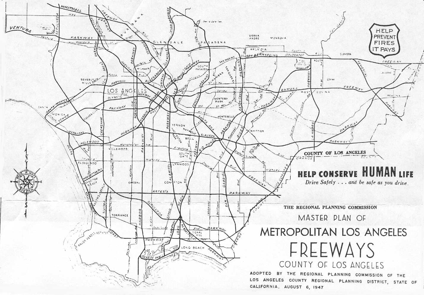
Metropolitan Freeway Plan (1947)
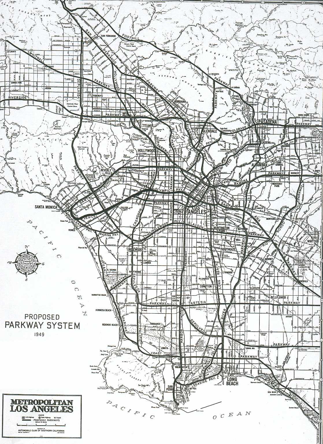
AAA Los Angeles Freeway Plan (1949)
Los Angeles Freeway Plan (1958)
Culture & Tourism maps:
Interactive Downtown Map
Rock & Roll Road Map
Public Art Maps of Downtown & Chinatown
Interactive Downtown Map
Rock & Roll Road Map
Public Art Maps of Downtown & Chinatown
Political & District Maps:
Census Tract Map
LA City Zip Code map
Congressional Districts in LA City
State Senate Los Angeles Area district maps
State Assembly District maps
County Supervisorial District Maps
LA City Council District Maps (current and past)
LAUSD Board of Education District Map
Neighborhood Council maps
CRA Project Area maps
An unofficial, inaccurate map of LA Communities (This map is a place to begin to understand the varied communities of the City - many of which are misrepresented on or missing entirely from the map.)
Housing, Planning, & Zoning:
Los Angeles City Limits Map
How Big is LA? map
Community Plans and Planning Area maps
Animated Census Maps (1940 to 1990)
Affordable Housing Maps (2004)
Housing Authority Units (by various districts)
WPA Landuse Maps (1930s)
Population Density (in comparison to New York City)
Transportation:
Los Angeles Scenic Highway Map
Freight Movement Map
Highway & Freeway Maps
Transit Priority Map
Non-Motorized Transportation Map
City Bikeways Map
Pedestrian Routes Maps to LAUSD Schools
New LA Marathon Route map
LAX Maps
LAX Noise Contour Maps
Van Nuys Airport Noise Contour Maps
Walkable Neighborhoods Map (via UCLA with explanation of what it means to be "walkable")
Downtown Parking District & Central City Parking District
Commute Times in LA County (1990)
Metropolitan Freeway Plan (1947)
AAA Los Angeles Freeway Plan (1949)
Los Angeles Freeway Plan (1958)
Public Safety Maps:
Pedestrian Routes Maps to LAUSD Schools
LAPD Crime Maps
Gang Territory Maps (from streetgangs.com)
Los Angeles Police Department Divisions
Brush Clearance Zones
LA Flood Hazard Map
Graffiti Removal Contractors
Hate Crime Maps (1999; pages 5, 11,13,15, & 17)
Natural Resources:
Oil Pipeline Map
Oil Fields in Los Angeles
Oil Wells
Used Oil Certified Collection Centers mapped
Hyperion Wastewater (Sewer) Treatment 5 Mile Outfall Inspection map
Tree Roots in the Sewer Map
Historic Earthquakes
Los Angeles Area Earthquake Map (within the last week)
LA River (& Tributaries) map
LA Flood Hazard Map
Los Angeles Area Earthquake Map (within the last week)
LA River (& Tributaries) map
LA Flood Hazard Map
Geologoic Maps of Los Angeles
Landslide Zones Map
Liquefaction Zones Map
High Wind Areas of the City
Maps of LA's pickable fruit (from the public right-of-way, via the Fallen Fruit Project)
Landslide Zones Map
Liquefaction Zones Map
High Wind Areas of the City
Maps of LA's pickable fruit (from the public right-of-way, via the Fallen Fruit Project)
Human Services:
Youth Data Mapped in the City (by council district)
Existing and Proposed Libraries map (1/07)
Seats Needed in 2020 in LAUSD (2002)
Maps of Downtown Homeless (from cartifact.com)
First Care Panel Medical Facilities Map
Other Maps & Repositories:
Interactive City Maps (Zimas, iMapLA, NavigateLA)
Healthycity.org (This website allows you to create maps and find data on health and human services from Infoline, nonprofits from the Center for Nonprofit Management, all public schools in Los Angeles County, and various landmarks.)
"Living Independently Los Angeles" (via UCLA)
Everything you need to know about mapping: CSUN's Map Library (mostly on site and not online).
http://www.davidrumsey.com/ is a good place to search for maps, as is the Union Collection (via the Huntington).
The Los Angeles Public Library also has a collection - not online - of useful maps.

8 comments:
Nice post. I'll have to go over it closely. Thanks for linking to the good highway maps, including the maps on my site, California Highways. So you know, I also have a blog where I talk about all sorts of stuff over on LiveJournal.
Amazing resource. Bookmarked!
- Atwater Village Newbie
This is great. I love maps. My thesis exhibition was called self organized mapping.
For now I'm working on a project where I photograph the border of Los Angeles, I'm starting on the outer borders and then going to do the cities within the border. My issue is getting a map that is accurate enough. If anyone has any ideas where I could, I would appreciate the help. I wonder if any city agencies have a GPS border map, but I don't know where to start.
For now I've imported the annexation map (the borders map is not to scale but this one is) into google earth, I'm then drawing a line over the border and exporting it as a GPS waypoint file so I can go find it in the real world.
PS great blog overall! Keep up the good work.
Have you seen these LA maps? They are interesting mash-ups
Price Per Sq FT of property:
http://www.propertyshark.com/mason/Maps/MAP/?map=la&basemap=pricesqft
Land Use:
http://propertyshark.com/mason/Maps/?map=la&basemap=landus
Density of Singles:
http://propertyshark.com/mason/Maps/?map=la&basemap=singlemen
Mapjack.com showcases a new level of mapping technology providing top quality Street Level Images, Street Level Pictures, Ground Level Pictures, Road Maps, Online Map Directions, Pictures of City, San Francisco, California.
Mapjack.com showcases a new level of mapping technology. What others have done with NASA budgets and Star Wars-like equipment; we’ve done on a shoestring budget, along with a few trips to Radio Shack. Specifically, we developed an array of proprietary electronics, hardware and software tools that enable us to capture an entire city’s streets with relative ease and excellent image quality. We have a complete low-cost scalable system encompassing the entire work-flow process needed for Immersive Street-Side Imagery, from picture gathering to post-processing to assembling on a Website.
For partnership, advertising opportunities, or to sponsor a new area please send us your feedback at http://www.mapjack.com/feedback.html
Nice article, Thanks for sharing, check out my work on Neighborhoods in Los Angeles
This is a fantastic resource for anyone interested in learning more about Los Angeles.
This is an incredible resource—thank you for compiling such a comprehensive list of LA maps across so many unique categories. As someone working closely with communities throughout the greater Los Angeles area, having access to historical, transportation, and human services maps like these is invaluable for understanding how the city has evolved and how to best serve its residents today.
At Reliably Safe Secure Med Transport, we depend on accurate, detailed navigation tools every day to provide timely and respectful medical transportation across Los Angeles. Whether it’s a routine appointment or specialized non-emergency ambulance transport in Los Angeles, maps like these—especially those tied to health services and infrastructure—help us better coordinate our services for maximum comfort and efficiency.
Post a Comment