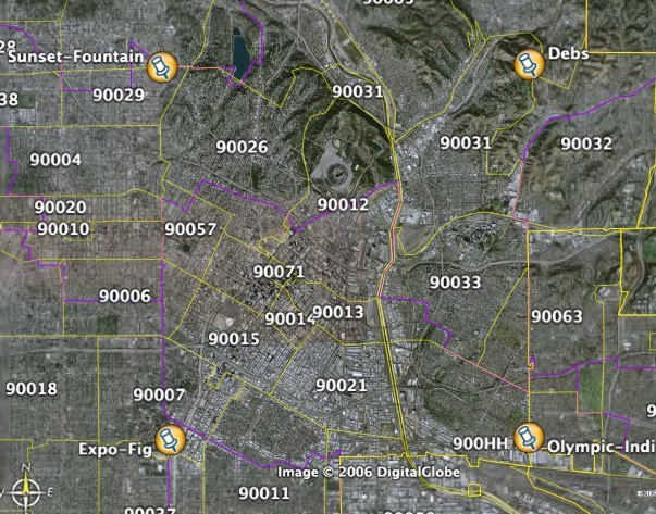
With 3 of them marked with plaques, the City's original borders' corners were easy:
Ernest S. Debs Park marks the northeast corner,
Sunset Boulevard and Fountain Avenue mark the northwest corner,
Olympic Boulevard and Indiana Street mark the southeast corner, and
Exposition Boulevard and Figueroa Street mark the southwest corner.
All but the last location have plaques denoting the location as an original City corner by the L.A. City Historical Society.
And then, the City grew and grew and grew...

5 comments:
...and the locations of the first two City Halls were located where??? Are there plaques marking these locations?
The plaque at Sunset/Fountain is actually located at KCET, about 1/2 block west of that intersection.
And yes, those two streets normally run parallel to each other, but not in Silverlake, where the "grid" gets all diagonal and twisty.
Note that the original west boundary is marked by Hoover St. from north to south. The old streets from downtown to Hoover run northwest-southeast, the original orientation of the pueblo streets. This also points to the early expansion to Highland Park and Pasadena. Right at Hoover to the west the grid starts, and the steets go north/south & east/west and have regular 4-way compass-points intersections---except, as we all know, for the numerous exceptions & the fade-out of the grid as it reached Doheny.
Just to clarify... the fourth plaque is currently in storage. It exists; it's just not placed.
Also, the original City was 28 square miles, not 25.
When did the city expaqnd to Eastern Ave. and Western Ave.? What where the north-south borders?
Post a Comment